Atlantis Found? The Eye of the Sahara and Plato’s Lost City
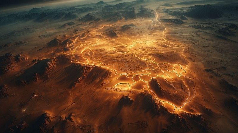
Imagine standing in the middle of a place unlike any other on Earth. You are now in the heart of Mauritania, amidst the arid Sahara Desert, surrounded by nothing but silence and endless stretches of sand. But if you ascend a few hundred kilometers into the sky, you will find yourself looking directly into a giant eye gazing into space. This is the Richat Structure, also known as the Eye of the Sahara. It is a mysterious geological formation spanning forty kilometers in diameter. For many years, scientists believed it was merely a crater resulting from a massive meteor impact. However, the truth that has recently begun to unfold may shake the foundations of history as you know it. Could this place be the true site of the lost city of Atlantis, described by the Greek philosopher Plato over two millennia ago?
Plato’s Blueprints: Concentric Rings and Precise Dimensions
Consider the description Plato left us with meticulous detail. He stated that Atlantis consisted of concentric circles: three rings of water and two of land. When you look at satellite images of the Richat Structure, a shiver will run down your spine. You see alternating circles there that appear to have once been waterways and quays for a great city. The measurements are terrifyingly precise. Plato specified the city’s diameter as approximately 127 stadia, an ancient Greek measurement. When we convert this number to modern units, we find it equals roughly thirty-eight kilometers. This figure aligns almost perfectly with the Richat Structure’s forty-kilometer diameter. Is it merely a geological coincidence? Or are you looking at the ruins of humanity’s greatest civilization?
Geographical Alignments and a Greener Sahara
Examine the geographical details surrounding this structure. Plato said that the city was protected from the north by towering and beautiful mountains, and opened to the south onto a rectangular plain extending towards the sea. If you open a map of Mauritania today, you will find the Adrar mountain range surrounding the Eye of the Sahara from the north, exactly as Plato described. To the south, a vast plain extends, which was once rich in water and pastures. Modern science tells us that the Sahara Desert was not always an arid wasteland. Approximately twelve thousand years ago, this land was green and teeming with life. There were massive rivers and giant lakes covering the region. Scientists have found fish and whale bones, as well as structures of marine creatures, in the middle of these sands. This suggests that the ocean once reached this area, or that a catastrophic flood swept through it.
Colored Stones, Ancient Springs, and the Cataclysmic Timing
Plato mentioned that the city’s stones were quarried from underground in three colors: red, black, and white. When you travel to Mauritania and examine the rocks in the Richat Structure, you will find these three colors precisely dominant in the rock formations: black igneous rocks, red sedimentary rocks, and white limestones. Every detail mentioned in the ancient manuscripts resonates in this forgotten corner of the African continent. You are now looking not just at silent rocks, but at a mystery spanning thousands of years.
Plato also mentioned that Atlantis had two springs, one cold and one hot. Geologists have confirmed the presence of ancient hydrothermal activity in that area within the Richat Structure.
Consider the timing Plato set for the sinking of Atlantis. He said it sank nine thousand years before his time, which is approximately eleven thousand six hundred years ago from today. This date aligns perfectly with a geological period known as the Younger Dryas. During that time, Earth experienced catastrophic climate changes and a sudden rise in sea levels. Could this rise have destroyed the civilization at the Richat Structure? Geological evidence in the region indicates a colossal flood that swept everything in its path towards the Atlantic Ocean. The sands within the Richat Structure appear to have undergone violent scouring by rapidly flowing water, an event akin to the catastrophic natural disasters documented throughout history.
Lost Technology, Primitive Tools, and Forgotten Maps
You might now ask yourself, why haven’t we found advanced technological remains or metals? The answer may be shockingly simple. Time, sand, and water are capable of erasing any physical trace within a few thousand years. Nevertheless, hundreds of thousands of prehistoric stone tools are scattered around the Richat Structure. The area was densely populated in that distant past, to an extent that seems illogical. Were these the survivors of the catastrophe? Did a great civilization devolve into primitive societies after losing everything overnight? The idea of highly advanced but forgotten societies is not new, as seen in Puma Punku’s inexplicable architecture or the Vimana aircraft of ancient India.
Look at the ancient maps drawn by early historians like Herodotus. In his map, drawn two thousand five hundred years ago, he placed Atlantis in the northwestern part of Africa, in the region where Mauritania is located today. He did not place it in the middle of the Atlantic Ocean, as modern cinematic imagination often does. The ancients knew something we have forgotten. They possessed accurate geographical records passed down from earlier civilizations. But over time, truth transformed into legend, and the city became a fairy tale told to children.
Academic Resistance and the Rewriting of History
Every piece of this puzzle seems designed to fit precisely into this location. You are facing a reality that transcends imagination. The African continent, long considered by some to be the cradle of humanity, may also be the cradle of the greatest lost civilizations, much like Göbekli Tepe challenged established historical timelines.
Why does the traditional academic community reject this idea? Because acknowledging it would require rewriting the entire history of humanity. It would require us to admit that we are not the pinnacle of evolutionary progress, but perhaps merely shattered heirs of ancestors who surpassed us in understanding the Earth and the cosmos. The fear of the unknown makes us cling to easy and safe narratives. But the truth remains there, etched into the topography of Mauritania, awaiting those with the courage to look at it honestly. The forbidden history often reveals itself in unexpected ways.
Frequently Asked Questions
What is the Richat Structure, also known as the Eye of the Sahara?
The Richat Structure is a large, circular geological formation spanning forty kilometers in diameter, located in the Mauritanian desert. Initially thought to be a meteor impact crater, recent theories suggest it could be the remains of the lost city of Atlantis due to its unique concentric circles and other geological features.
How does the Richat Structure align with Plato’s description of Atlantis?
Multiple details align: its concentric ring structure, its approximate diameter (40 km vs. Plato’s 38 km), surrounding mountains to the north and a plain to the south, the presence of black, red, and white rocks, and evidence of ancient freshwater and hydrothermal springs within its center. Furthermore, the timing of its potential destruction aligns with the Younger Dryas period, a time of catastrophic global floods.
Why haven’t advanced technological remains been found if the Richat Structure was Atlantis?
The text suggests that thousands of years of exposure to sand and water could have eroded or covered any physical traces of advanced technology. However, hundreds of thousands of prehistoric stone tools have been found in the area, suggesting a densely populated region after a major catastrophe, possibly by survivors who lost their civilization’s knowledge.
What historical and geological evidence supports the Richat Structure as Atlantis?
Historical maps from figures like Herodotus placed Atlantis in northwestern Africa. Geologically, the Sahara was a green, water-rich region around 12,000 years ago, consistent with Plato’s timeline. Evidence of ancient marine life and massive floods further supports the theory that the area once had a strong connection to water, possibly the ocean.
Why is the theory that the Richat Structure is Atlantis largely rejected by mainstream academia?
Acknowledging this theory would require a fundamental rewriting of human history, challenging established narratives about the timeline of civilization and technological progress. The academic community often prefers more conventional and easily verifiable explanations, as accepting such a claim would have profound implications for our understanding of human development.